NileSim
Overview
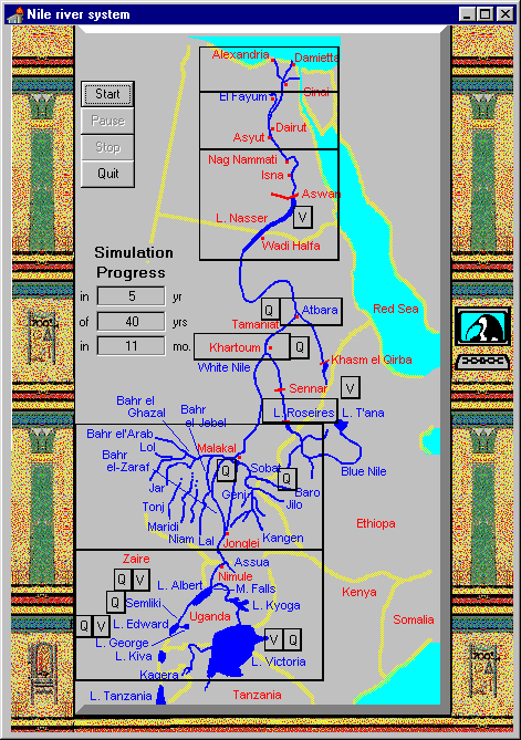
The development of river basin policy and management plans involves a spectrum of concerned parties and organizations, only a small fraction of which are represented by technical professionals. Easily-used and highly-interactive computer simulations provide a means by which these individuals can develop both a conceptual and an intuitive understanding for the complex physical behavior of river systems. NileSim is a graphical simulator of the complete Nile River Basin, which has been developed principally for the pedagogical purpose of explaining complex river behavior and management to non-technical people. The simulator has been developed in a cost-effective manner, making use of modern software development tools from electronic design automation. This has provided a rigorously accurate tool, which is fast, graphically intuitive, and simple for people to use. The tool supports interactive experimentation with a simulated Nile River Basin for users to learn by observation how that basin system works.
The United Nations Environment Programme (UNEP) has reviewed NileSim (pp. 51-54) in its report “Water Sharing in the Nile River Valley“, carried out under its Project GNV001: Using GIS/Remote Sensing for the Sustainable Use of Natural Resources.
Download
- NileSim simulator file (2000) [Download] – Vissim file with monthly data files
- NileSim v1.0 (1997) [Download] [Instructions]
Publications
Levy, B. and Baecher, G. (1999).
“NileSim: A Windows-Based Hydrologic Simulator of the Nile River Basin.”
J. Water Resour. Plann. Manage., 10.1061/(ASCE)0733-9496(1999)125:2(100), 100-106.
Participants
- Greg Baecher
- Ben Levy
- Gary W. Rubloff
Map by Ryan D., Paul N. and Jason B. of Oak View Elementary School, Fairfax VA.